7 MIN
TRAVEL TIPS
Mt. OLYMPUS 2917m: WALKING TRAILS OF MYTH

For those having greater stamina, there is an alternative towards Kalogeros. The whole route takes three days at a leisurely pace in the summer (mid June to mid September). Little equipment is needed since you can sleep and eat at the refuges. Of course you should have a warm change of clothes as well as a waterproof outer garment (Olympus is known for its afternoon showers).
On the first night you can stay at either of the refuges on the Mousson Plain and the second night at a bivouac outside so you will require the appropriate equipment (sleeping bag, food etc.). The route is not difficult and the trails are well kept and well marked. Even the gullies leading to the summits are marked and all that is required is a little caution and common sense. Conditions are a little more difficult if it is early summer and snow still remains on the rock bands rendering their passage more difficult. Things are tougher still for those who go to Kalogeros since the paths are not that well marked and there is no water to be found.
If you climb the mountain in July or August and especially during weekends, you will come across many more mountaineers since during the summer Mt. Olympus is probably the most frequented mountain in Greece.
Litochoro - Mitikas – Litochoro : We begin our trek from ‘Diastavrosi'- exactly 13.5 kms from Litochoro on the Litochoro-Prionia road. A small road branches up and to the left, which takes us to a clearing from which the trail begins. Beginning rather steeply and traversing a very beautiful forest, an hour’s walk along the well-marked trail brings us to ‘Barba’ at an elevation of 1450m where there is a clearing with benches. Then the trail ascends a little and then descends until the junction for Itanos spring, which doesn’t always have water. A steep ascent brings us to the area known as “pangakia". Here we are provided with a nice view of the Enipeas valley, the Monastery of St. Dionissios, and Kalogeros summit.
Keeping within the woods, the trail continues to ascend until “Strangos” where there is a water tank (which doesn’t always contain water). From here a trail branches to the left towards the Mousson plain via “Anathema”, which as its name suggests in Greek, is extremely steep and not recommended. We continue straight ahead and to the right. The forest begins to thin and the beech-trees aree replaced by pines.
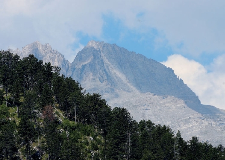
Soon we reach “Petrostrunga” at about 1950m. Here among the pines which are hundreds of years old we find several sheepfolds. Up to here we average about 1:45hrs from “Barba”. The trail winds mildly through huge trees that slowly thin; a sign that we are approaching the alpine zone. And sure enough, soon we come out on arid ground. The well-trodden path and the intense markings make sure we don’t get lost. Now we see a bare incline which the trail slowly ascends. To our righright we see magnificent valleys and cliffs descending from the Mousson plain. Spectacular peaks, that grow in even the steepest of places: a medley of valleys and ridges provide a picture of the remote grandness of Olympus.
We reach the foot of “Skourta” peak (2485m) where we find a sign. We proceed to make a quick ascent of it. Time from Petrostrunga is 1:15hrs. Here we are provided with our first view of the peaks of Olympus as well as the Mousson plain. Unfolding in front of us is the only passage toward the plain; the Skourta neck (“lemos”) and “Yiosso’s” pass. We descend a little until the lowest point of “lemos” and then the trail takes us to the base of the plain (the steel cables are for winter ascents). The base of the plain is at 2600 2600m. From here we can follow the right row of poles to the SEO refuge at 2710m or the left row to the EOOA refuge at 2650m. Both are built across from Stefani. Time from “Skourta” to here is 1:15hrs for a total of 5:30hrs from “diastavrosi”. If you have enough time, we strongly recommend that you climb the peak of Profitis Ilias, which will reward you with a spectacular view.
To continue for the summits, we take the trail from SEO refuge, which traverses the base of Stefani. This almost level path takes us to a ridge where we see the “Zonaria” (“bands”), “Mavrolongos” and the Enipeas valley. We can also make out the refuge of Spilios Agapitos. Five minutes from here brings us to the markings that will guide us through the Stefani gully to the secondary peak of Stefani. From this point to the main peak we need to traverse a very exposed pass. Some basic mountaineering experience is required.
If we return to the trail to a point a little lower than the Stefani gully, we find other markings -red again- which lead us through the Mitikas gully to the peak of Mt. Olympus. Scrambling is also required here. However the markings, almost at every meter, make our life easier. From the peak we have an endless view of half of Greece and of the rest of Olympus. This, providing that the peaks are not surrounded in one of the usual fogs of the mountain. From the refuge to here is about 1:15hrs. Notice that we are on the summit and we do not toss rocks since there may be people below us who are climbing or walking. We descend the same route to meet the “Zonaria” trail. The path descends mildly until it intersects the trail that ascends from Spilios Agapitos refuge to Skolio. We follow it and gradually enter the pine forest. The trail descends rather steeply only on a ridge and we reach Spilios Agapitos refuge rather quickly. The entire trail from the Skolio intersection until Litochoro is part of the E4, the international trail that crisscrosses Greece.
From the refuge the trail descends steeply. Above and below it are hundreds of tree trunks from avalanches that melt in the spring and flow off the Zonaria bands just above. We re-enter a dense forest which gradually becomes beech-tree magnificent forest of silence-until we come out at the waterfall of Prionia. This point is accessed by a road from Litochoro. There is a refreshment store and of course a lot of noise. We fill our water bottles and quickly enter the E4 trail which follows the Enipeas river. The route from the base of Mitika to Prionia takes about 3:30 to 4 hours. From here on, after crossing to the left bank (north) of the river, and passing through romantic clearings to the deserted Monastery of St. Dionissios at an elevation of 820m.
After the Monastery we descend until the river, cross it until we come out at the cave of St. Dionissios where there is a spring. From here the trail ascends and descends to the left and to the right of the river (the crossing in early summer requires a jump in the cold water) passing pools ideal for bathing. After the last crossing of the river (five in all from Prionia), the trail starts ascending the right (south) side of the valley across from the Zilnia rock face. After gaining elevation (luckily the path winds through a dense forest so the sun doesn’t bother us) we finally view Litochoros at the end of a plain. In a while the trail at last starts to descend until it reaches the outlying houses of Litochoro(4 hours).
INFO : Elevation 2,917 m (9,570 ft), Prominence 2,355 m (7,726 ft), Location Greece Range Macedonia and Thessaly, near the Gulf of Salonika Coordinates 40°05’08’N 22°21’31’E GPS ROUTES LINKS TO DOWNLOAD TREKKING | Litochoro - Enipeas - Prionia Olympus http://www.anevenontas.gr/en/routes/?tid=1330854611
Submitted by Miltos Zervas: Reach me at info@anevenontas.gr
http://www.anevenontas.gr


